New Brunswick
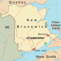
New Brunswick is Canada's only official bilingual province. It is 85% covered by forest, which is the terrain of most of the interior of this province. New Brunswick is the largest of Canada's three Maritime Provinces and mainly surrounded by coastline. The Baie des Chaleurs, Gulf of St. Lawrence, and Northumberland Strait are warm-watered with sandy beaches, attracting beachgoers. The Bay of Fundy is quite the opposite, drawing only whale-watchers and kayakers to its chilly waters. The seaport of Saint John is a historic town to visit, with a weather-beaten quality and many restored 19th century wood and brick homes. Harbor seals are also a common sight in this area. Another interesting town is St. Stephen, just 66 miles west of Saint John. The chocolate bar was invented here, so the town is a fantasy for chocoholics. In early August a festival is held devoted entirely to chocolate. St. Andrew by-the-Sea is a beautiful resort town 18 miles southeast of St. Stephen. It has long served as a summer retreat for the affluent and is a designated National Historic District. Other points of interest include the fishing village of St. Martins, Fundy National Park, Edmunston, Fredericton, and Kings Landing Historical Settlement. New Brunswick is bordered on the east by Prince Edward Island and the Gulf of Saint Lawrence, on the north by Quebec, on the south by Nova Scotia and the Bay of Fundy, and on the west by the State of Maine in the USA. The mildest time weather-wise to visit New Brunswick is late spring through early fall. There are festivals celebrating almost everything from jazz to salmon. Recreational activities include canoeing, kayaking, golfing, and skiing. New Brunswick Government LinksNew Brunswick Tourism Links
Copyright © 2006-2024 Canada-Maps.org.
All rights reserved. Canada Maps - New Brunswick |