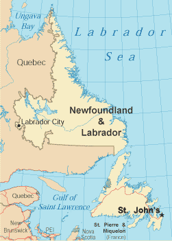
Newfoundland and Labrador
Vikings from Iceland and Greenland arrived on the island of Newfoundland creating the first European settlement in North America. It quickly became known for its abundance of cod fish and grew into a crowded harbor. For centuries, Newfoundland was the largest supplier of salt cod in the world. 700 outposts dotted the coast of Labrador, 400 of which still survive. The capital of Newfoundland and Labrador is St. John's, located on the Avalon Peninsula. It is not only North America's oldest city, but its most easterly point. In addition to the Avalon Peninsula, other areas of interest are Cape St. Mary's Ecological Reserve, Terra Nova National Park, the Bonavista Peninsula, and Notre Dame Bay. Expect Newfoundland and Labrador to have excellent seafood, warm hospitality, and sharp-witted folks. Locals are very welcoming to visitors both on the mainland of Labrador and the island of Newfoundland (pronounced New-fund-land), and won't hesitate to share some valuable travel tips. Quaint bed and breakfasts abound on the island and the mainland, and ferries travel frequently between both. Newfoundland and Labrador is bordered on the east by the Atlantic Ocean, on the north by the Labrador Sea, on the west by Quebec and the Gulf of Saint Lawrence, and on the south by Quebec and the Atlantic Ocean. Seasons vary dramatically in Newfoundland and Labrador, and the tourist season usually runs from June through September. During this time there are many festivals, fairs, concerts, plays, and craft shows. Recreational activities include fishing and wilderness hikes, golf, scuba diving, sea kayaking, and whale watching. Newfoundland and Labrador Government LinksNewfoundland and Labrador Tourism Links
Copyright © 2006-2024 Canada-Maps.org.
All rights reserved. Canada Maps - Newfoundland and Labrador |